If you are in the Salt Lake Area and would like to get out and knock off a couple of the top hikes in the State and a few calories; here are some ideas. I also included a couple easy hikes as well if you are just feeling lazy. There is no cost to do any of these hikes. Be aware, dogs are not allowed on the trails in Big Cottonwood Creek Canyon where many of the best trails are found….so plan appropriately.
Mt Olympus

Mt Olympus is easily visible from downtown Salt Lake City which makes it one of the most popular hikes in the State. Located to the south of downtown, it lies between the entrances to the Big and Small Cottenwood Creek Canyons. The trailhead is easily accessible at “about” 5800 Wasatch Blvd. The parking lot was under construction when I did this hike but there was plenty of parking along the road. The trailhead is easily visible and it lies parallel to I-215 between exit 4 and 6. The hike takes you up to the Bonneville Shoreline Trail where you turn south (right) and follow the shoreline trail for about 0.5 miles. That is where the trail splits off to the left and heads up….up….and more up.

The trail has been well traveled and even though there are few…ok….no trail markings; its easy to follow. Did I mention to go up?

You are supposed to cross a creek about half-way along the trail, but it was dry in August. The first two miles….other than being up….were not very difficult and took about an hour. (Did i mention up?) The third mile however was much steeper and very rocky which slowed me down considerably. The last half mile involved bouldering and trying to find the best way to scramble to the top; which was actually quite a bit of fun…..if you like life terrifying events. Of course, as I was doing this, the thought of: “how the hell am I going to get back down with all my bones and blood in my body?”, was silently was running though my mind.

The top of the mountain is covered with large boulders randomly piled on top of each other which you need to make your way across to your ultimate goal: a mailbox someone carted up to the top with a book in it where you can log your name with the other tens of thousands who had climbed all the way up.

The view, of course was the real payoff and the knowledge that you accomplished one of the tougher hikes in the State.

Climbing down was slow and took as long as climbing up. The trail is 3.65 miles one way with an elevation gain of 4,200 feet and took me about three hours one-way. I definitely wasn’t the fastest one on the trail and I did see several runners coming down…..which would be nuts on this trail. I was pleasantly surprised to make it to the top before several young college students. However, the most interesting person I met near the top, as I was coming down, was a young man with only one arm. I couldn’t imagine his determination. He had hiked/jogged up the mountain and was bouldering with one arm. I told him how impressed I was and he commented that he had done it before. He passed me on the way down.
This is the one hike in the area that everyone likes to say they did…..once.


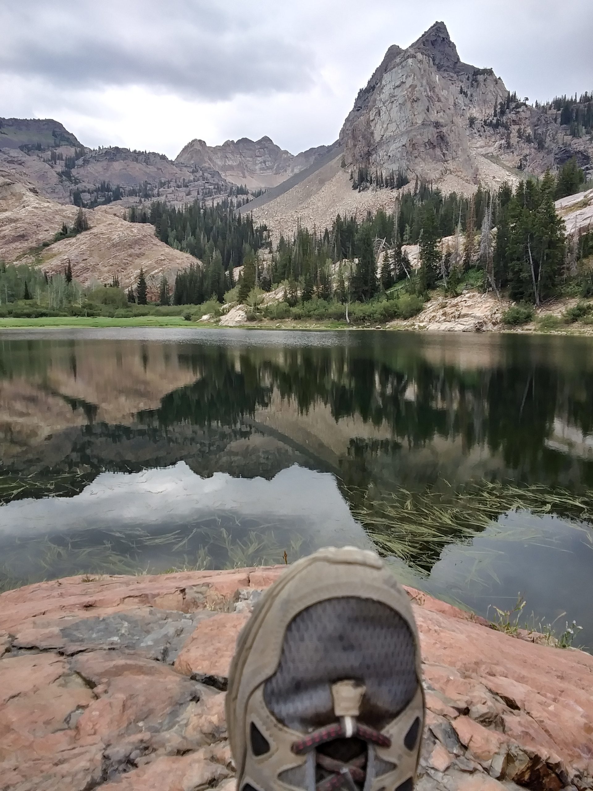
Lake Blanche:

If Mt Olympus sounds a bit too intense but you still want a good hard challenge, Lake Blanche may be perfect for you. It is a 2,800 foot climb over 3.35 miles but you are paid off with one of the most beautiful alpine lakes you may ever see. The trailhead is in Big Cottenwood Creek Canyon at the Mill B tailhead. There is plenty of parking and the trail begins on a paved path along a stream..After about 0.25 miles you make a sharp right (before you cross a bridge) and head up.
The trail follows a creak at the beginning and is fairly rocky. I was advised by one of the Forest Service employees that it was a bear of a hike but well worth it, and he was correct. The trail had been heavily traveled and was easy to follow.


The trail goes up 2,800 feet to an altitude of 8,920 feet.

The hike is mostly shaded and scenic throughout. I was on the lookout for moose but they were well concealed in the woods.


One of the most beautiful settings I have seen in Northern Utah ….. of course once I got settled in …….. it started to rain for the first time in a month. The hike down was relatively easy but you have to pay attention when you cross a small boulder field.

Easy Hikes in the Area:

Hidden Falls:

From the same parking lot as Lake Blanche Trail, you can go across the road at the “S” curve and take a short trail 0.25 miles up the stream to hidden falls. Not spectacular but well worth the effort. Climbers also frequent the area, so you might see several working on their skills along the cliffs.

Donut Falls:

Donut falls is located just a few miles up Big Cottenwood canyon and is one of the most popular hikes in the area. The trailhead for the falls is located down the Mill D Southfork Road at the Sprouces Campground. There is a small parking area at the trailhead. A larger parking lot is located on the Big Cottenwood Creek Canyon road which will add about two miles roundtrip to your hike. The hike from the trailhead is only 0.75 miles each way which makes it very child friendly. I had been told to avoid the falls on the weekends due to large crowds.

The falls actually goes through an opening in a rock; hence the name “Donut Falls”. The last little portion of the hike requires you to cross the stream multiple times and you may get a little wet. The water is shallow and cold but the rocks may be slippery.

If you go up the falls you can actually wade into a small cave and get next to the falling water.
Silver Lake:

If you continue up Big Cottenwood Canyon you eventually will end up at the Silver Lake Visitor Center and Parking lot. The trail around Silver lake is about a mile long and level (based on Utah Standards) and provides you the opportunity to explore several other lakes in the area.

There are restrooms and a large paved parking lot here. The area is very popular with families, children……
I hope this gives you some ideas of things to do if you are traveling in the Salt Lake Area for a few days and want to see a few of the many highlights in the area with some elevation.
UTAH: LIFE ELEVATED….afterall.
