I think all of us have seen the pictures of the multicolored sandstone in western desert that resemble rainbows in the earth. But can you get to it? What does it take? Is it worth the effort?

I started to research the hike to the Wave back in the summer while I was “social distancing” on my computer, which is kind of what I do even when there isn’t a pandemic. I was pleasantly surprised when I learned that the hike is typically conducted out of Kanab, Utah. Kanab has been a special place for our family over the years and a great location to visit Zion, Brice and Grand Canyon (North Rim) National Parks and of course the Coral Pink Sand Dune State Park. However, in my multiple visits to the area, when our kids were actually kids, I had never heard of hikes to “the Wave”.


My first thought was…..lets go! We could drive over to Kanab from Salt Lake in about 5 hours. Spend the night, do the hike and be back the next day. A quick google search however, dashed my hopes. First, a permit is required for the Coyote Buttes North, Special Management Area where the wave is located and only 20 individuals are allowed access each day. Next there is no marked trail. Also, a four-wheel drive vehicle is required to access the trailhead much of the year. OK, so this is now not as much of a hike as it is a challenge. And I love a good challenge.

Permit Process:
In order to get a permit, you can apply online or attend a daily lottery for the permit in Kanab. Ten individuals are selected from each group and issued permits for the 24-hour period. So, we could drive down to attend the lottery, spend the night and do the hike the following day. Cool! Piece of cake! Oops, not so fast, the average number of people apply daily for permits at the lottery is 50 and there have been as many as 350! OK, that won’t work. Well what if we just went without a permit? $10,000 fine and a month in jail……not a good idea.

So how about the on-line process? OK, there is a $9 charge to apply in addition to the permit fees. The permit fees $7 per person and $7 per dog. Fees per dog…that is awesome! Also, you are applying on-line for a specific day four months in the future. Now that is an interesting twist. So, an application submitted in August is for the lottery conducted Sept 1st for dates in December. There are no changing dates or refunds. So, you are at risk if the weather turns bad or if something gets in the way…like Covid-19. But what the hell its only $9.


On the application, I could put in for up to three dates. So, I went for the first weekend in December since that might be warmer. I forgot all about the process until about mid-September. I had not seen any emails from the BLM and assumed that I didn’t get a permit. I didn’t want to do it in January (due the weather) so I thought we were out of luck until the spring. However, I did a quick glance at my spam folder and what do you know, an email from the BLM. “You have one day left to claim your permit”. Oh, we won and I need to check my spam folder more often.

Planning for the trip
“Reva….remember that permit I applied for last month for that hike to the pretty rocks in Arizona. We won! We are going in December. I don’t know if our Prius can make it to the trailhead and I don’t know how long the hike is and there is no marked trail. They say people get lost often and never find the Wave but most eventually find their way out, but we will be OK.” A husband knows when his wife is not happy. “Don’t worry, I will rent a four- wheel drive vehicle and buy a portable GPS unit….it will be OK.” A husband knows when his wife is not happy. “Maybe I can find someone to take us out to the trailhead and wait for us while we hike.” A husband knows when his wife is not happy. “You know, I bet I can find a guide to take us out and hike with us so that we know we won’t get lost and find the Wave.” I nervous smile came across Reva’s face. “It does look very pretty.” Ok, next how to find a reasonably priced guide.

When the permit arrived in the mail a few weeks later, there was a list of approved guides included. As I went though the list, I found that many specialized in photography or didn’t provide transportation. Several were closed for the season or Covid…or both. The going price for a private guide for a couple with transportation was $300 to $350 plus tax and tip. The first one I contacted happened to be out of Las Vegas and required full prepayment. When I looked into the company’s background, I became concerned. Eventually, I stumbled on Coral Cliffs Tours and Townhomes. Jeff Jenson was the owner and a local resident. The cost was $150 per person plus tax and tip and there was no prepayment required. Excellent….guide booked…..ready to go!

The Hike:

Lara was our tour guide and she was perfect. She arrived at the Hampton Inn Kanab (17,000 HH points) promptly at 8:00 in a jeep. We quickly climbed in and we were off. Reva was relieved that Lara went out to the Wave frequently and had just been there. Lara had two teenage boys and her and Reva hit it off only like two mothers could. I did learn more about making gravy and noodles than I needed to know but it made for a great atmosphere.

The drive out to House Rock Valley Road was a very familiar 38 miles along route 89. House Rock Valley road connects route 89 and route 89A through public lands. The Wire Pass Trailhead was a little over 8 miles south on Rock Valley Road. The road itself was not too bad and a car could make the drive and several did. However, if there had been some rain that would have been different. Anyway, Lara and the Jeep made quick work getting us to the trailhead and we were off on the hike by 9:00.

The temperature when we started was 18 degrees but with the sun, we found ourselves removing layers fairly quickly. A ranger is out on the trail daily but we didn’t see him until we had gotten back to the parking lot. Since much of the hike was on rock, you could understand how it could get very warm quickly.

Along with the permit, the BLM provided a brochure with a map and set of pictures that showed the major points along the trail.

The first portion of the trail follows Coyote wash and is a very easy hike. The trail is marked and turns off to the right. Coyote Wash continues and leads to Buckskin Gulch, the longest and deepest slot canyon in the Southwestern US and worth a future trip.

The trail was easy to follow until we reached the sliprock. The sliprock extends most of the way at this point to the wave, probably about 1.5 miles. This is the area where people can get lost and the BLM has installed 4 post directing hikers in the correct direction.

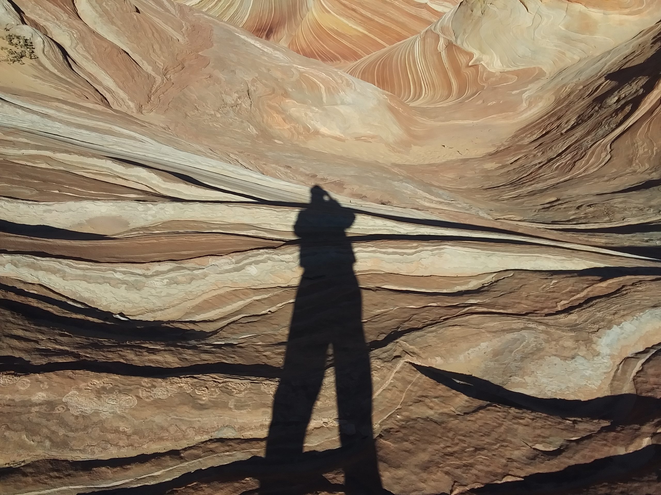
When you reach the last trail marker, you can see a shadow on a rock face in the distance which is caused by a vertical crevice. It is very distinctive…looks kind of like a vagina. The bottom of the crevice points directly at the Wave.

The last portion of the hike requires going up a sand dune which is the most strenuous portion of the hike. The hike was about 3.5 miles one way. Unfortunately, GPS was a little sketchy in the area and my watch couldn’t accurately measure the distance.

In addition to the Wave, there were several other rock formations and even some dinosaur footprints which added to the hike.

Lara was a great guide and took away any concern of getting off of the trail or missing the Wave. She was quite surprised that we had gotten a permit on our first try and told us stories of people trying daily for a week or more to get a permit.

The Wave itself is only about the size of a football field and the Coyote Buttes area is vast. I could see how people could easily hike all day and never find it. Bottom line….hiring a guide was a good investment….and good company.

On the way back we passed several others heading out to the wave including a group of six Asian women who were starting the hike later in the day without a guide. Not a good idea, “they won’t make it there and back before dark”, Reva commented. Lara agreed and said “there are at least two guides out there behind us and the ranger will be around, so they will be alright.”

We made it back to car and headed back to Kanab. We got back to town around 2:30 in the afternoon with plenty of time to make it back to Salt Lake City that evening. We had plenty of pictures and great memories. Before we left Kanab, we stopped in a little thrift shop next to the hotel. I bought a 1,000 piece puzzle which I felt was a good souvenir for the hike. We solved the Wave puzzle….now time for something a little less complicated.


Cool! Very, very cool! Would love to take that trip! Is the trail wheelchair friendly? BLAHAHA!
Great hike…you should check it out…wheelchair et all